

North Descent.
1-mile scramble off Chapel Pond is steep enough to earn a demanding alpine rating despite covering less ground than most parking lots. The route drops fast over exposed rock and roots, demanding full attention for every step. It's a thigh-burner in reverse if you're climbing out, and a white-knuckle descent if you're heading down.
- Leg-stretcherShort and nearly flat — an hour or less
Seasonal pattern for this trail · tops out ~2,051 ft · live closures appear above
- GroundSurface
- User-createdStatus
Read the line before you walk it.
What the trailhead is doing today.
Where the hike begins.
What the route itself carries.
Summits reached, waters touched, and the lean-tos along the way — read it like a cue sheet, mile posts ascending.
Curated trailheads & parking near this route.
Editorial trailhead listings within roughly 3 miles — permit info, parking capacity, and access-road conditions.
Guides, outfitters & shuttles.
If you’re already out here.
Keene.
The corner of the Park this trail calls home — its hamlets, waters, lodging, and the rest of its field record.
Read the Region→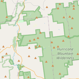
Make a weekend of it.
Closest editorial picks for a meal, a scoop, a pint, a bed, and a sight worth your time.
Eat.
4- Noon Mark Diner4.2 mi
A traditional diner experience, offering hearty meals for travelers and locals in the Adirondack Park.
- Ausable Inn4.4 mi
Comfortable Keene Valley restaurant, bar, liquor store, and small inn. American comfort menu — wings, fish and chips, Montreal brisket, steak au poivre, plus the locally famous Hungarian mushroom soup.
- Forty Six8.0 mi
A small fine-dining room on Route 9N in Keene at the Dartbrook Lodge campus, with a seasonal menu that rotates regularly and elegant plating. Reservations recommended.
- The Deer's Head Inn Restaurant9.2 mi
The Deer's Head Inn is a historic Elizabethtown tavern and restaurant — among the oldest inns in the Adirondacks — serving pub fare and regional dishes.
Sip.
4- Old Mountain Coffee Company4.2 mi
Great Coffee, Great Food, Great Baked Goods & Great People. Stop in to enjoy our house roasted coffee, browse our menu for a bite to eat or grab a delicious treat from our bakery. Order Online for pickup or stop in.
- Counter Space9.3 mi
A casual cafe in Elizabethtown serving coffee, espresso, and light bites — a local gathering spot in the Essex County seat.
- Pleasant Valley Cafe9.3 mi
A local cafe in Elizabethtown serving breakfast, lunch, coffee, and comfort food in the heart of the Boquet Valley.
- Life Church Cafe9.4 mi
Life Church Elizabethtown is a local church dedicated to connecting lives and building community.
Sweet.
4- Black Rooster Maple8.2 mi
Pure Adirondack Maple Syrup, Maple Cream, Bourbon Barrel Maple Syrup
- Cedar Run Bakery & Market8.7 mi
Cedar Run Bakery & Market offers scratch-made baked goods, deli items, fresh menu options, and take & bake meals, alongside a selection of wine and spirits. They are open Friday through Monday from 8 AM to 6 PM.
- Sugar House Creamery14.2 mi
Sugar House Creamery is a farmstead creamery located in the Adirondacks, producing artisanal cheeses from the milk of their own cows. They offer a variety of cheeses, showcasing the quality of their local dairy.
- Adirondack Corner Store14.2 mi
A longtime deli and general store at the corner of Route 73 in Lake Placid with an ice cream counter and subs — a locals' spot off the Main Street tourist row.
Drink.
4- The Old Mine12.7 mi
The Old Miners Tavern is a historic Adirondack tavern in Moriah, NY, offering classic bar food like juicy burgers and chicken wings, a full bar with rotating craft beers, and a welcoming atmosphere for friends to gather.
- Paradox Brewery13.2 mi
Paradox Brewery offers a diverse tap selection, a full menu with pizza, burgers, and BBQ, and an expansive mountain landscape.
- The Knock ADK15.0 mi
The Knock ADK is a restaurant and bar in Westport, NY, offering a plant-based dinner menu alongside classic and craft cocktails. They provide dinner reservations on non-show nights and welcome walk-ins on show nights.
- Lake Placid Pub & Brewery15.5 mi
A brewpub on Mirror Lake Drive in Lake Placid since 1996, with 12 house beers on tap including the original Ubu Ale, a downstairs Irish pub, and a deck over Mirror Lake.
Stay.
4- Rooster Comb Inn4.3 mi
Rooster Comb Inn is a dog-friendly inn located in the heart of Keene Valley, NY, offering comfortable, rustic lodging within walking distance to Adirondack trailheads and local eateries. It features shared amenities like a full kitchen and…
- Keene Valley Lodge4.5 mi
A seven-room lodge and three-bedroom cottage at the center of Keene Valley, with breakfast and direct walk access to the Great Range trailheads and village restaurants.
- The Halfway House Motel7.6 mi
A small motel with an on-site restaurant on Lobdell Lane in Elizabethtown, the Essex County seat between the Northway and the High Peaks. Simple rooms for travelers passing through or basing for a day in the Adirondacks.
- Dartbrook Lodge8.0 mi
A small lodge on Route 9N in Keene offering individually furnished cottages and suites in the Great Camp tradition, many with kitchens and private porches. The High Peaks trailheads start a few miles up the road.
See.
4- Hurricane Mountain Fire Tower7.1 mi
Perched atop Hurricane Mountain, this historic fire tower provides hikers with unparalleled 360-degree views of the Adirondacks, Lake Champlain, and Vermont's Green Mountains.
- Keene Arts8.4 mi
Keene Arts is a venue in Keene, NY, hosting diverse events including art exhibits, concerts, film screenings, and a winter farmers market.
- Adirondack History Museum9.4 mi
The Adirondack History Museum in Elizabethtown tells the story of Essex County and the Adirondacks — pioneer life, mining, tourism, and mountain heritage.
- Lake Placid Bobsled Experience10.5 mi
Mt Van Hoevenberg, a Lake Placid Legacy Site, offers the thrilling Skeleton Experience for visitors and youth bobsled and skeleton programs, continuing its Olympic legacy as a venue for winter sports.
Add to the record.
Free, takes thirty seconds. Yours forever.
Every page on this site gets better when readers contribute. Mark a peak you’ve climbed, drop a photo, file a field note, or flag a correction — every addition makes the next visitor’s page better.
File a report.
Trail conditions, water level, bug pressure, blowdown. The kind of detail that helps the next person plan.
Write a field note →Spot something off?
Wrong elevation, outdated access notes, a coordinate that's drifted. We'd rather hear it than miss it.
Suggest an edit →
Frequently asked.
- How long is the North Descent?The North Descent is approximately 0.06 miles (0.1 kilometers) — a short out-and-back suitable for most fitness levels.
- How difficult is the North Descent?The North Descent is rated alpine-grade (SAC T4 or higher) — scrambling and route-finding required, sometimes hands-on terrain. Check current DEC advisories for closures, washouts, or seasonal restrictions before heading out.