1. Why the Adirondacks for paddling
There is no other place in the eastern United States — and arguably no other place east of the Boundary Waters of Minnesota — where a paddler can string together as many wilderness lakes, rivers, and short connecting carries as in the Adirondack Park.
The Park holds more than three thousand lakes and ponds and thirty thousand miles of rivers and streams; our own catalogue lists four hundred and thirteen named waters. Within those waters are designated wilderness areas closed to motorized craft, century-old portage routes still in active use, the largest wilderness canoe area in the Northeast, two long-distance water trails of national stature, and an annual ninety-mile race that has been run continuously since 1983.
For the paddler who plans a serious trip, the Adirondacks reward the planning. For the visitor who wants a flat, glassy hour on a quiet lake at sunset, the same Park delivers that too. And for the traveler who wants the experience of a multi-day wilderness expedition without ever being more than thirty miles from a working village with hot dinner and dry sheets — this is the rare landscape where that is genuinely possible.
We treat paddling as one of the brand’s flagship verticals. The data graph, the cross-link engine, and the editorial weight of this guide all support the trip planner who shows up with a paddle in the truck and a four-day weekend ahead of them.
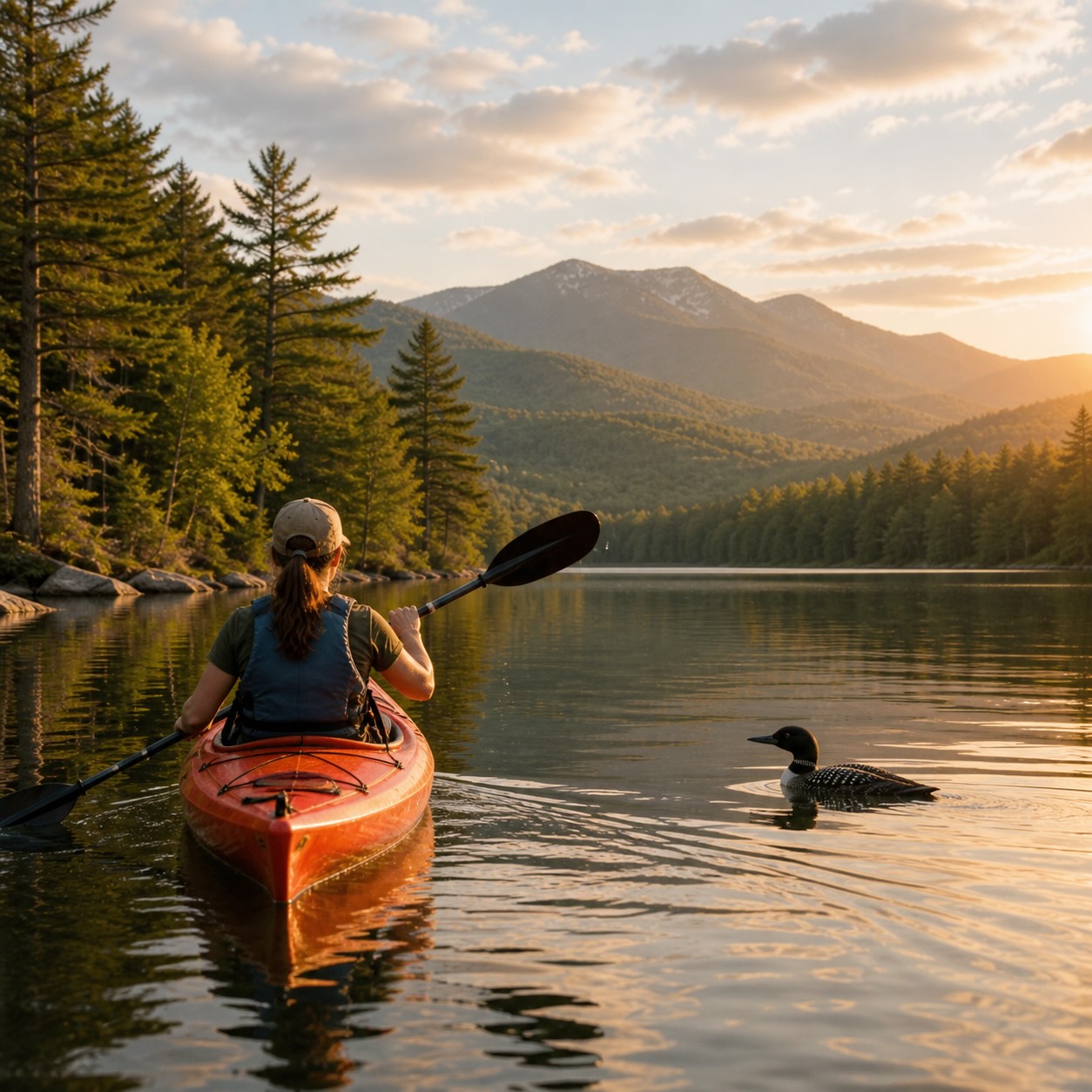
Paddling in the Park is not a single activity. Sea kayakers on Lake George are doing something genuinely different from canoe-campers on St. Regis Pond, who are doing something different from packboaters on the Bog River, who are different again from ultralight racers on the 90-Miler. Choose the discipline that matches your skill, your boat, and your week — and we will help you find the water for it.
2. The four kinds of paddling water in the Park
The Park’s waters fall into four broad categories. Knowing which one you’re heading for changes the boat, the gear, the skill demand, and the schedule.
Type 1 — The big motorized lakes
Lake George (thirty-two miles long), Lake Champlain (the Park’s eastern boundary), Schroon Lake, Indian Lake, Great Sacandaga Lake, Raquette Lake, Tupper Lake, Long Lake, Cranberry Lake, and the lower halves of the Saranac chain. Open to motorboats and powerboats. Beautiful in the early morning before the wakes start; choppy and exposed in the afternoon. Best for sea kayakers with skill in open-water conditions, or for early-morning paddlers willing to be off the water by 10 a.m. on summer weekends.
Type 2 — The wilderness canoe waters
The St. Regis Canoe Area, the William C. Whitney Wilderness, the Five Ponds Wilderness, the Cranberry Lake Wild Forest interior. Closed or substantially restricted to motorboats. Quiet, primitive, often requiring carries (portages) between waters. The signature Adirondack paddling experience — and the one this guide is most concerned with helping you plan well.
Type 3 — The flatwater rivers
The upper Raquette, the Bog River, the Oswegatchie, parts of the Saranac River, the Marion River. Slow-moving, lake-like rivers that can be paddled in either direction with reasonable effort. Often the most productive way to reach interior waters and lean-tos.
Type 4 — The whitewater rivers
The Hudson Gorge, the Moose River, parts of the Sacandaga, the lower Ausable. Class II to Class V depending on the section and the water level. Outside the scope of this guide; pursue with a guide service the first time, and never alone.
The major paddles on the map
The marquee paddles in the Park, plotted shore-to-shore. Pick a route to see its line and the lakes, towns, and outfitters it passes within a few miles of.
The Bog River from Lows Lake to Tupper Lake — quiet flow through a rare boreal corridor with one carry around the Lower Dam.
Single carry at Lows Lower Dam (short, well-marked). Boreal habitat: spruce-tamarack lowlands, bog mats, and good chances at moose, otter, and black-backed woodpecker. Put-in at Lows Lake landing off CR-10A; takeout at Bog River Falls or in Tupper Lake village.
Geometry is hand-digitized for visualization, not turn-by-turn navigation. Always carry the relevant paddler’s map (ADK or NFCT) and check current water levels and carries before you launch.
3. The St. Regis Canoe Area
The headline is the headline. The 18,400-acre St. Regis Canoe Area is the only designated canoe area in New York State, and the largest wilderness canoe area in the Northeastern United States. It is closed to motorized vehicles, motorboats, and floatplanes. It contains roughly fifty ponds and lakes ranging from a half-acre unnamed pond to the 401-acre St. Regis Pond. Most are connected by short trails — carries — that paddlers walk between waters, boat balanced on shoulders.
The closest large reference point is Saranac Lake, about ten miles to the southeast. The eastern access is via Paul Smith’s; the southern via the Fish Pond Truck Trail and Floodwood Road; the western via Long Pond. There are five primary public-access launch points: Hoel Pond, Long Pond, Floodwood Pond, Little Clear Pond, and Upper St. Regis Lake.
The Seven Carries
The classic introductory route. Goes from Little Clear Pond (south) to Lower St. Regis Lake (at Paul Smith’s College). The route passes through four ponds connected by short, well-defined carries. The path dates to the late 1800s, when paddlers used it to travel between Paul Smith’s Hotel (now Paul Smith’s College) and the Saranac Inn, of which only the golf course remains. Allow most of a day. Lighter is better — wheeled portage carts are technically allowed but troublesome on most of the trails.
The Nine Carries
The deeper, multi-day version. Nine portages link a chain that includes Long Pond, Nellie Pond, Kit Fox Pond, Little Long Pond West, Fish Pond, Mud Pond, Ochre Pond, St. Regis Pond, and Little Clear Pond. Most paddlers do this as a two- or three-night canoe-camping trip. Experienced paddlers can do it in a long day. The longest single carry is at the start; from there the carries shorten and the ponds open up. Wheels are not recommended.
St. Regis Pond and the island camping
The largest pond in the canoe area at 401 acres, with two islands that offer the rarest kind of Adirondack camping experience: a true island to oneself for the night. Tent sites are first-come, first-served. There are no reservations. If you arrive at dusk on a holiday weekend, every site may be taken. The reward, when you do find an open island, is the silence — no motors, just bird calls in daylight and loon calls after dark.
The introductory loop. Little Clear Pond to Lower St. Regis Lake via four ponds. A full day, lighter boats preferred.
The deeper traverse. Best as an overnight expedition. Pack boats over canoes; some carries reward minimalism.
Put in at Little Clear Pond, paddle 1.5 mi, half-mile carry, paddle 1 mi, camp on an island. A first canoe-camping trip done well.
Outfitters who specialize in the canoe area include St. Regis Canoe Outfitters, Adirondack Lakes & Trails Outfitters, and Mac's Canoe Livery. All three rent boats, run shuttles, and lead guided trips into the canoe area.
4. The Saranac Chain
Three large lakes — Lower Saranac, Middle Saranac, and Upper Saranac — connected by short carries and a narrow connecting channel called the Saranac River corridor. The chain runs roughly southeast to northwest, with the village of Saranac Lake at the southeast end and the historic Saranac Inn site at the northwest. The classic Saranac Chain paddle traverses all three, exiting at the head of Upper Saranac near Indian Carry, and is one of the great regional paddle days in the Park.
Unlike the St. Regis Canoe Area, the Saranac Chain is open to motorboats. Plan early-morning starts. The chain also holds several public island campsites — coveted, often booked in summer — and lean-tos on the shore. Reservations go through the New York State campsite system; book ahead in July and August.
The Saranac Lakes Wild Forest
The lands surrounding the chain are protected as Wild Forest, holding seventy-six named peaks, dozens of secondary ponds, and connecting water trails. The interior small ponds — Weller, Floodwood, Fish Creek — see less traffic than the main chain and reward exploratory days.
5. The Fulton Chain of Lakes
Eight numbered lakes in the western Adirondacks, running from Old Forge (First Lake) east through Fourth Lake to Eighth Lake — the longest interconnected lake chain in the Park. Old Forge is the western terminus, Inlet sits between Fifth and Sixth, and Raquette Lake lies just east via a short channel. The Fulton Chain is the western paddler’s equivalent of the Saranac Chain — open to motorboats but with quiet shoulder-hours, deep regional paddling history, and connection to the broader water network of the central Adirondacks.
The Fulton Chain is also the start point for the 90-Miler, the Adirondack Canoe Classic (see Chapter VIII). From a touring standpoint, the chain is best enjoyed by paddling from Old Forge east to Fourth Lake (about sixteen miles) over a long day, with the option to extend through the eastern lakes via short, navigable channels.
The anchor outfitter for the Fulton Chain is Mountainman Outdoor Supply Co. in Old Forge — boats, gear, NFCT support, and 90-Miler logistics.
6. The Raquette River
The Raquette is the longest river entirely within New York State and the spine of paddling in the central Adirondacks. From its source at Raquette Lake, the river flows north through Long Lake, Tupper Lake, and onward to the St. Lawrence. The most-paddled section for multi-day trips runs from Long Lake to Axton Landing — about twenty miles of largely flatwater paddling broken by one significant carry around Raquette Falls (1.25 miles, the longest carry in any of the classic ADK water routes).
Raquette Falls is the moment a casual paddler discovers what a long carry actually means. Plan the carry: light boats, organized gear, and an honest accounting of how many trips it will take to move everything across. Mosquitoes and black flies are at their worst on this carry in late spring and early summer. The reward, on the other side, is the lower Raquette — wider, slower, and one of the great river-camping stretches in the Northeast.
Other notable river paddles
- The Bog River from Lows Lake — a slow, dark, scenic flow through wetland country, with put-in at the lower dam and the option to extend deep into the William C. Whitney Wilderness.
- The Oswegatchie twisting through the Five Ponds Wilderness, requiring multiple days and serious wilderness preparedness. One of the most committing river trips in the Park.
- The Marion River connecting Raquette Lake and Blue Mountain Lake, short and historically important — the route Adirondack guideboat history was largely written on.
- The Indian River, Schroon, and upper Hudson all hold paddleable sections of varying difficulty. The upper Hudson north of the gorge is flat and forgiving; check current levels before you commit.
7. The Northern Forest Canoe Trail
A 740-mile water trail from Old Forge, NY to Fort Kent, Maine — running through the Adirondacks, Vermont, Quebec, New Hampshire, and Maine. The Adirondack section covers roughly the first 140 miles, from Old Forge through the Fulton Chain, Long Lake, the Raquette, the Saranac Chain, and out via the Saranac River toward the Champlain Valley. Few paddlers attempt the full 740 miles; many attempt the Adirondack section over one to three weeks.
The NFCT is a useful organizing concept even for shorter trips: the official maps, the published portage notes, and the recognized campsite list are all genuinely helpful planning resources. The Trail’s stewardship organization publishes section maps, condition reports, and a code of trail ethics. Even paddlers who never set out to “do” the Trail end up using its infrastructure on routine multi-day Adirondack trips.
8. The 90-Miler
The Adirondack Canoe Classic — universally called the 90-Miler — is a 90-mile, three-day flatwater paddling race held the weekend after Labor Day. It runs from Old Forge to Saranac Lake village, traversing the Fulton Chain, Raquette Lake, Forked Lake, Long Lake, the upper Raquette River, the Saranac chain, and most of the historic Adirondack water route between west and east. Paddlers compete in canoes, kayaks, guideboats, war canoes, and stand-up paddleboards, in solo, tandem, and team divisions.
The 90-Miler is, more than a race, the largest social event in Adirondack paddling. Hundreds of paddlers, support crews on the carries, end-of-day stops in Inlet and Long Lake. Registration opens in spring and fills before summer. For the strong recreational paddler, it’s a tractable challenge with built-in support. For the casual visitor, the carries — especially Raquette Falls on Day 2 — are some of the best people-watching in the Park: a small army of paddlers and crew members shouldering boats over a mile-long trail.
“There is something special about having an island to oneself. It is a rarity anywhere in the world, but possible in a few places in the Adirondacks.”
9. For first-timers — where to put in
If this is your first time in a boat in the Adirondacks, the right water is small, motorboat-free or shoulder-hour-quiet, and within twenty minutes of a real village. Six recommendations, sequenced from easiest to most ambitious.
Right in the village. Town launch and outfitter rentals at the south end. Paddle for an hour and walk to dinner. The training wheels of Adirondack paddling.
No-wake; 5 mph maximum; electric motors only. The walkable lake at the heart of Lake Placid. Rent at the boathouses and paddle the loop.
At the Adirondak Loj. Small, scenic, no motors, and the introductory High Peaks view from your boat. Day-use access through the ADK Loj.
Big enough to feel like a trip; small enough to start at one launch and finish at another. Start at First Pond, paddle to Ampersand Bay.
The single-carry version of the Adirondack canoe-camping experience. The right first overnight — pack light and aim for an open island.
Long, narrow, with public sand beaches and lean-tos along the eastern shore. Paddle to a beach, swim, picnic, paddle back. Best with kids.
10. Sortable atlas of major paddles
A working reference of the named waters most worth your day. Each row links to the full lake page in the catalogue, which surfaces nearest lean-tos, primitive campsites, outfitters, lodging, and put-in locations.
The full sortable atlas — every named water in the Park — lives at /lakes. Filter by region, by access type, by motor restrictions, and by best-for category. The selection below is the editorial shortlist.
| Water | Region | Type | Motors? | Best for | Tier |
|---|---|---|---|---|---|
| St. Regis Pond | Paul Smith's | Wilderness pond, 401 ac | No | Canoe-camping, island sites | Flagship |
| Upper St. Regis Lake | Paul Smith's | Lake, 738 ac | Limited | Day touring, Seven Carries | Flagship |
| Long Pond | St. Regis Canoe Area | Wilderness pond | No | Nine Carries put-in, hiking access | Flagship |
| Hoel Pond | St. Regis Canoe Area | Wilderness pond | No | Family carries, day loops | Strong |
| Lower Saranac Lake | Saranac Chain | Lake, 2,200 ac | Yes | Day touring, public island camping | Flagship |
| Middle Saranac Lake | Saranac Chain | Lake, 1,376 ac | Yes | Quieter middle of the chain | Strong |
| Upper Saranac Lake | Saranac Chain | Lake, 5,000+ ac | Yes | Sea kayaking, big-water touring | Strong |
| Lake Flower | Saranac Lake village | Impoundment | Limited | Beginner, walkable village access | Beginner |
| Mirror Lake | Lake Placid | Lake, 128 ac | Electric only | Beginner, no-wake village paddle | Beginner |
| Heart Lake | North Elba (ADK) | Pond, 16 ac | No | Beginner, High Peaks view | Beginner |
| Long Lake | Central Adirondacks | Lake, 14 mi long | Yes | Family touring, lean-to camping | Flagship |
| Forked Lake | Central Adirondacks | Lake, 1,248 ac | Yes | State campground access, day paddling | Strong |
| Raquette Lake | Central Adirondacks | Lake, 5,274 ac | Yes | Big-water touring, Great Camp history | Flagship |
| Blue Mountain Lake | Central Adirondacks | Lake, 1,288 ac | Yes | Day touring, museum access | Strong |
| Fourth Lake (Fulton) | Old Forge / Inlet | Lake, 2,107 ac | Yes | 90-Miler course, classic chain | Flagship |
| First & Second Lakes (Fulton) | Old Forge | Lakes | Yes | 90-Miler start, family touring | Strong |
| Lake George | Lake George region | Lake, 32 mi long | Yes | Sea kayaking, island camping | Flagship |
| Schroon Lake | Schroon | Lake, 4,233 ac | Yes | Family touring, beach access | Strong |
| Indian Lake | Indian Lake | Lake, 4,365 ac | Yes | Big-water touring, Lewey Lake access | Strong |
| Cranberry Lake | Cranberry Lake | Lake, 6,975 ac | Yes | Wilderness touring, lean-to camping | Strong |
| Tupper Lake | Tupper Lake | Lake, 5,800+ ac | Yes | Big-water touring, NFCT access | Strong |
| Lows Lake | Bog River Flow | Wilderness lake | No | Bog River paddle, multi-day camping | Flagship |
| Little Tupper Lake | Whitney Wilderness | Wilderness lake | No | Reservable wilderness camping | Flagship |
Best paddling waters by region
Best for: Multi-day chain paddling, wilderness canoe-camping, beginner village water. The deepest paddling concentration in the Park.
Top waters: Lake Flower, Lower Saranac Lake, Middle Saranac Lake, Upper Saranac Lake, the St. Regis Canoe Area, and the Stony Creek Ponds.
Best for: Motor-restricted village paddling, trailhead lakes, sea-kayak-grade big-water touring on Lake Placid itself.
Top waters: Mirror Lake, Lake Placid, Heart Lake, and the Chubb River corridor.
Best for: Family-friendly chain paddling, the start of the 90-Miler, NFCT entry.
Top waters: Fourth Lake, First through Eighth Lakes, Limekiln Lake, and the short channel into Raquette Lake.
Best for: Long-day touring on big quiet lakes, river-camping on the Raquette, NFCT corridor.
Top waters: Tupper Lake, Long Lake, the upper Raquette River, and the Bog River flow into Lows Lake.
Best for: Big-water touring, deep cold lakes, less-pressured wilderness paddling.
Top waters: Indian Lake, Lewey Lake, Cranberry Lake, and the Cedar River Flow.
Best for: Sea kayaking, island camping, big-water touring on a thirty-two-mile lake.
Top waters: Lake George, Schroon Lake, and Pharaoh Lake (paddle-only, hike-in).
Launches & the famous carries
Where to put in, and the short connecting trails between waters that turn isolated ponds into a multi-lake route. Carries (portages) are the defining piece of Adirondack canoe-area travel — the canoe-area, the NFCT, and the 90-Miler all string together via these.
Marquee paddle launches
The DEC, NYS Parks, and the Adirondack Mountain Club maintain the public launches below. Marina-style launches (Lake George, Bolton Landing, Old Forge) are listed in the marina directory; the entries below are paddle-priority — small, often gravel or carry-down, with paddler parking and minimal motor activity.
| Launch | Water | Region | Type | Fee | Parking | Notes |
|---|---|---|---|---|---|---|
| Saranac Lake Islands HQ launch | Lower Saranac Lake | Saranac Lake | DEC public launch | Free for paddlers (camping permits separate) | Large paved · paddler-priority | Anchor for the Saranac Chain. Paddler-priority parking, AIS inspection on site. Walk to a campsite reservation kiosk. |
| Second Pond / Indian Carry launch | Second Pond | Saranac Lake | DEC public launch | Free | Gravel · ~15 cars | Trailhead for the Indian Carry over to Upper Saranac. Classic Saranac-Chain itinerary entry point. |
| Floodwood Pond access | Floodwood Pond | St. Regis Canoe Area | DEC public launch | Free | Gravel · paddler-priority | Single launch into the Fish Creek / Floodwood / St. Regis Canoe Area. Most-used canoe-area entry. |
| Long Pond launch | Long Pond | St. Regis Canoe Area | DEC public launch | Free | Small gravel lot · ~10 cars | Launches into the canoe-area's southern ponds. Nine Carries put-in. |
| Little Clear Pond launch | Little Clear Pond | St. Regis Canoe Area | DEC public launch | Free | Small gravel lot | Half-mile carry to St. Regis Pond — the single most-used canoe-camping launch in the canoe-area. |
| Long Lake town launch | Long Lake | Long Lake | DEC public launch | Free | Paved · large lot | Launch for Long Lake itself + the 90-Miler course's Long Lake leg. Restrooms in town. |
| Forked Lake DEC campground launch | Forked Lake | Long Lake | State campground | Day-use fee · season | Paved · large lot | DEC campground with paddle-in tent sites. Direct access to a quiet 1,248-acre lake. |
| Raquette Lake South Inlet | Raquette Lake | Raquette Lake | DEC public launch | Free | Gravel · ~30 cars | Marquee Raquette-Lake launch. Big-water touring, Great Camp shoreline, public island camping (paddle-in). |
| Blue Mountain Lake town beach launch | Blue Mountain Lake | Central Adirondacks | DEC public launch | Free | Paved · ~20 cars | Small launch with sandy beach. Day touring, Adirondack Experience Museum walking distance. |
| Old Forge town launch | First Lake (Fulton) | Old Forge | DEC public launch | Free | Paved · large lot | 90-Miler start. Anchor for the Fulton Chain. Restrooms + outfitters within walking distance. |
| Heart Lake (ADK Loj) put-in | Heart Lake | North Elba | ADK / nonprofit | ADK day-use fee | Gravel · ADK Loj lot | 16-acre pond at the Adirondak Loj. No motors. Beginner-friendly with a High Peaks view. |
| Mirror Lake (Lake Placid) launches | Mirror Lake | Lake Placid | DEC public launch | Free · several boathouses rent | Street + boathouse lots | No-wake; 5 mph max; electric motors only. Beginner-friendly, walkable village. |
| Lake Flower launch (Saranac village) | Lake Flower | Saranac Lake | DEC public launch | Free | Paved · ~15 cars | Right in the village. Walk to dinner from the town launch. The training wheels of Adirondack paddling. |
| Lows Lake / Bog River put-in | Lows Lake | Tupper Lake | Carry-in / paddle-only | Free · permit for camping | Gravel · small lot | 100-yard carry to launch on the Bog River. Wilderness paddle into Lows Lake — primitive campsites only. |
| Little Tupper Lake (Whitney Wilderness) | Little Tupper Lake | Tupper Lake | Carry-in / paddle-only | Free | Gravel · ~30 cars | Strict no-motor / no-floatplane wilderness paddle. Primitive lakeside campsites, the canoe-area's southern cousin. |
The famous carries
The Adirondack carries are short walking trails (some under 100 yards, the longest just over a mile) that connect paddleable waters. Most are wheel-friendly with a portable canoe cart — the canoe-area culture is built around the wheels-and-paddle hybrid trip.
| Carry | Connects | Length | Surface | Wheels? | Notes |
|---|---|---|---|---|---|
| Indian Carry | Stony Creek Ponds → Upper Saranac Lake | 1.0 mi | Wide dirt road | Yes | The classic Saranac Chain connector. Wheels-and-paddle culture's signature carry. Drivable for shuttle support. |
| Bartlett Carry | Middle Saranac Lake → Round Lake | 0.5 mi | Smooth dirt path | Yes | Connects Middle Saranac to Round Lake en route to Upper Saranac. Pleasant gentle grade. |
| Spider Creek Carry | Upper Saranac Lake → Bay Pond | 0.4 mi | Forest path | Partial | Roots and a couple of short uphill sections — wheels work but expect to lift over a few obstacles. |
| Little Clear → St. Regis Pond | Little Clear Pond → St. Regis Pond | 0.5 mi | Smooth dirt | Yes | The single-carry trip to the canonical first canoe-camping overnight in the Park. Wheelable, mostly flat. |
| Floodwood Carry | Floodwood Pond → Fish Creek Pond | 0.3 mi | Sandy / smooth | Yes | Short connector at the eastern edge of the canoe-area. Often the first carry of a Floodwood loop. |
| Bog River Falls Carry | Lows Lake outlet → Bog River downstream | 100 yd | Steep dirt | No | Brief but steep — drag, don't wheel. Bypasses the falls at Lows Lake's outlet. |
| Hoel Pond Carry | Hoel Pond → Turtle Pond → Slang Pond | 0.4 mi | Forest path | Partial | First carry of the classic Nine-Carries loop in the canoe-area. Roots; expect a few obstacles. |
| Long Pond → Slang Pond | Long Pond → Slang Pond | 0.5 mi | Forest path | Partial | Mid-Nine-Carries connector. Wheeled on the dry stretches. |
| Round Lake → Saranac River | Round Lake outlet → Saranac River | 0.2 mi | Smooth dirt | Yes | Short carry on the Saranac River downstream paddle. |
| Buttermilk Falls Carry | Long Lake → Raquette River downstream | 0.3 mi | Forest path | Yes | Bypasses Buttermilk Falls on the 90-Miler / NFCT route. Well-worn, wheelable. |
| Raquette Falls Carry | Raquette River upstream → Raquette River downstream | 1.3 mi | Forest road | Yes | The longest carry on the 90-Miler course. Wheelable but a workout — most paddlers train for it. |
| Stony Creek Ponds → Saranac River | Stony Creek Ponds → Saranac River | 0.2 mi | Smooth dirt | Yes | Brief connector tying the upper Saranac River into the Stony Creek pond chain. |
Carry distances and surface conditions are editorial. Always carry the relevant ADK paddler’s map and check current AIS-inspection requirements before launching.
On the map
The named lakes that anchor the atlas, plotted alongside the regional outfitter network. The St. Regis / Saranac cluster around the Tri-Lakes is the densest, with secondary hubs on the Fulton Chain at Old Forge and on Long Lake.
- Lake George Kayak Co.Listing
- Beaver Brook OutfittersListing
- Mirror Lake BoathouseListing
- St. Regis Canoe OutfittersListing
- Lake Placid LodgeListing
- Mirror LakeLake
- Long LakeLake
- Raquette LakeLake
- Saint Regis PondLake
- Forked LakeLake
- Indian LakeLake
- Cranberry LakeLake
- + 3 pending coordinates
11. Outfitters and rentals
You don’t need to own a boat to paddle the Adirondacks. The outfitter ecosystem is mature — every major paddling region has rental, instruction, guide service, and shuttle support. The shuttle service in particular is what makes one-way trips possible: you launch at one put-in, take out at another, and the outfitter shuttles your car. Below, the operators we know best, by region.
The deepest knowledge base for the canoe area itself. Pack-boat rentals, guided trips, shuttles to and from canoe-area put-ins, gear sales.
Boat rentals, gear, instruction, multi-day trip planning support. Convenient downtown location for first-timers.
Lake Clear and Floodwood put-in proximity. Long-time presence in the region; good for shuttles into the canoe area.
Walk-up canoe and kayak rental in the village center. The right first hour on the water for first-time visitors.
The Fulton Chain anchor outfitter. Boats, gear, NFCT support, 90-Miler logistics.
Long Lake's anchor business. Boats, gear, ice cream, shuttle service, the bulletin board with all the local news.
Browse the full directory of paddling outfitters and guides at Pursuits or by region under Saranac Lake, Lake Placid, and Old Forge. The 90-Miler weekend, the Saranac Lake Winter Carnival paddle events, and regional canoe-and-kayak festivals are listed under Events.
12. When to paddle, when not to
The Adirondack paddling season runs roughly from ice-out (mid-April to early May, depending on the lake and the year) through ice-in (mid-November). Within that window, four sub-seasons each have a distinct character.
Spring (ice-out through Memorial Day)
Cold water, swollen rivers, peak migration for loons and waterfowl, no crowds, no bugs yet. Best for early-morning bird-watching paddles and for experienced paddlers who can dress for cold-water immersion (a capsize in 45-degree water is a serious event). Avoid whitewater unless you know the river at high flow.
Black fly season (Mother’s Day through late June)
Roughly Mother’s Day through the last week of June. Black flies emerge along moving water and torment paddlers and portagers. Bug nets, picaridin, and long sleeves are mandatory at the carries. The water itself is fine; the carries are the problem. We say so honestly because no tourism brochure ever will.
High summer (July and August)
The peak season. Warm water, long days, full outfitter operations, but also peak crowds on Lake George and the Saranac Chain, and peak motor activity. Paddle the wilderness waters during these months; reserve the motorized lakes for early mornings and weekday evenings.
Fall (Labor Day through ice-in)
Many locals’ favorite season. Cooler water, bug-free, fewer motorboats, foliage on the surrounding hills, and the 90-Miler the weekend after Labor Day. Pay attention to weather — fall storms can bring fast-changing conditions. Cold-water gear from late September on.
13. What to bring
For an hour on a calm lake
- The boat (rented at any put-in)
- A PFD that actually fits and that you actually wear
- A water bottle
- Sunscreen — the sun off water is brighter than you expect
- A waterproof phone case or dry bag
- A whistle clipped to the PFD
For a day trip
- A printed map (cell service is unreliable to nonexistent in the interior)
- A compass and the ability to orient it on the map
- Lunch in a dry bag
- Layers — synthetic baselayer and a wind shell at minimum
- A change of dry clothes left in the truck for after
- Headlamp — even for day trips that may run long
For an overnight or multi-day
- Backcountry-rated tent and sleeping bag
- Bear canister (required by NYSDEC in the eastern High Peaks; recommended throughout)
- Water filter or purification system
- Stove and fuel (open fires are restricted in many wilderness areas)
- Bug protection — head net, picaridin, long sleeves and pants
- Carry straps or yoke pads for portaging
- Repair kit: duct tape, marine epoxy, spare paddle
- Trip plan in writing, left with someone who is not on the trip
14. Leave No Trace and the carries
The paddling resource of the Park exists in the form it does because generations of paddlers, the state, and conservation organizations have protected it. The carries themselves — the short trails between waters — are the most fragile element in the entire system. They erode quickly under heavy use, and a poorly-maintained carry can take a decade to recover.
- Carry over, don't drag. Wheels are sometimes acceptable, sometimes not. When in doubt, shoulder the boat. A drag mark in the wet ground becomes a trench in three weeks.
- Camp at established sites only. The pond may look untouched but the established sites exist for a reason — they concentrate impact. Pitching a new tent site in the moss displaces a square meter of slow-growing groundcover.
- Pack out everything, including food scraps. The black bear population in the canoe area is healthy and habituated bears become problem bears. A peach pit at the carry is a peach pit at the carry; pack it out.
- Clean, drain, dry between waters. Eurasian milfoil, water chestnut, zebra mussels, and spiny water flea spread on hulls, in livewells, and in wet gear. The Adirondack Watershed Institute runs inspection stations at major launches — use them.
The Adirondack Mountain Club publishes the definitive paddler's maps for the canoe area and the Saranac chain — waterproof, tear-resistant, scaled for navigation. The Adirondack Council and Adirondack Watershed Institute run boat-wash stations and aquatic invasive species inspection programs at major launches. Use both. The maps will save you a wrong turn; the boat-wash stations protect the resource for the next paddler.
15. Frequently asked questions
Roughly mid-April to early May depending on the lake and the year — the Park's lakes and ponds melt out at different times. Lake George's shallow southern basin is paddleable earlier; the deeper interior canoe-area ponds may not be ice-free until the first week of May. The season runs through ice-in in mid-November.
No paddling permit is required on most public waters. State campsites in the canoe area and on the Saranac Chain are reservable through the NY State campsite system in peak season; primitive shoreline sites on most other waters are first-come, first-served.
St. Regis Pond — half-mile carry from Little Clear Pond, paddle to an island campsite, no motors, the experience of canoe-camping in a wilderness canoe area without committing to multi-day route-finding. Pair with an outfitter rental from St. Regis Canoe Outfitters or Adirondack Lakes & Trails Outfitters.
It depends on the carry, the boat, and the load. The Seven Carries are mostly short and well-marked. Raquette Falls (1.25 miles) is genuinely hard with a heavy boat and full gear. Pack boats and ultralight canoes turn long carries into manageable trips; aluminum canoes loaded with gear turn short carries into ordeals.
Yes — the 90-Miler is open to any paddler willing to register, train, and complete the course. Solo, tandem, and team divisions accommodate every boat type. Registration opens in spring and fills before summer; the race is the weekend after Labor Day.
Mirror Lake Boathouse in Lake Placid, the town launch in Saranac Lake village, and outfitters in Old Forge and Long Lake all rent by the hour. Walk-up rentals work for spontaneous evenings on calm village water.
Yes — St. Regis Canoe Outfitters, Adirondack Lakes & Trails Outfitters, and several regional guide services run multi-day guided trips into the canoe area, the Saranac Chain, and the Bog River. Expect $400–$700 per person per day depending on group size, route, and season.
Hug the shoreline in the early morning, off the water by 10 a.m. on summer weekends, and stay clear of motorboat lanes. Both lakes can build steep chop in afternoon wind that requires real sea-kayak skill — plan accordingly.
Outside the scope of this guide. The Hudson Gorge, the Moose River, parts of the Sacandaga, and the lower Ausable hold paddleable whitewater up to Class V. Hire a guide service the first time and never paddle whitewater alone.
NYSDEC publishes a list of primitive lean-tos and shoreline tent sites by water. The Northern Forest Canoe Trail's published section maps mark recognized campsites along the Adirondack corridor. Reservable sites in the canoe area and on the Saranac Chain go through the NY State campsite system; everything else is first-come, first-served.
Sources & further reading
This guide is editorial — written to help you plan well — and is not a substitute for current NYSDEC regulations, outfitter shuttle availability, or weather and water-level conditions on the day of your paddle.


