1. Why drive the Adirondacks
For a region the size of the Adirondacks — six million acres, larger than Yellowstone, Yosemite, Grand Canyon, the Smokies, and Glacier combined — the road network is the only practical way to see more than a tenth of it on a single visit. The Park is laced with state routes, county roads, and forest roads that together form one of the most rewarding scenic-driving landscapes in the eastern United States.
Eight of those routes carry official New York State Scenic Byway designation; one of them — the Lakes to Locks Passage — carries the further national designation as an All-American Road. Beyond the named byways, dozens of regional drives, foliage loops, and lakeside roads reward the traveler who treats the drive itself as the trip rather than the connector between trips.
This guide is built around two overlapping uses. The first is the marquee day-drive — pick a byway, plan a route with food and stops, take the day. The second is the connecting drive — the route that gets you from base to attraction, made purposeful by knowing what to look for along the way. We treat both with equal seriousness.
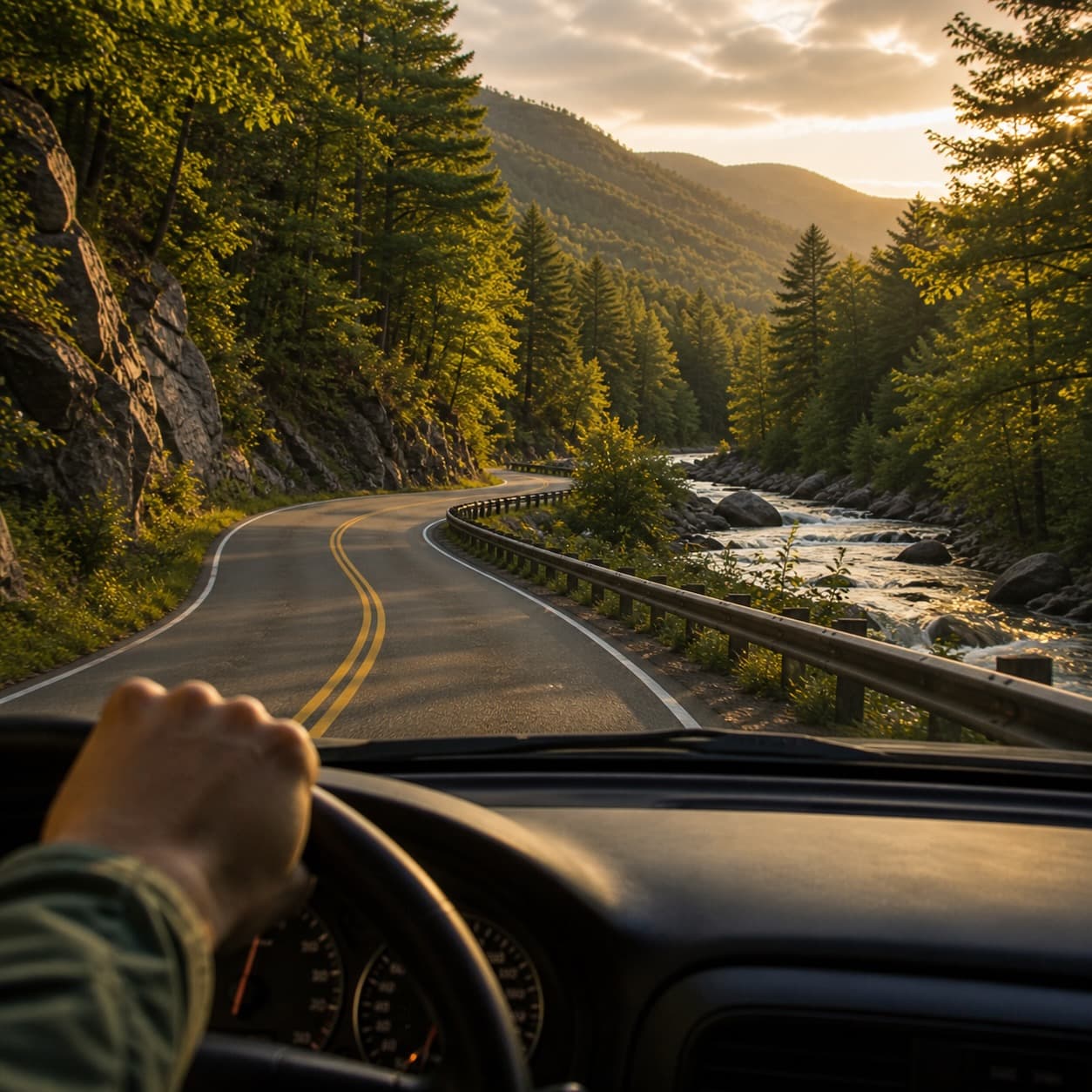
The Adirondacks reward the slow driver. The marquee scenery is rarely on the interstate; it's on the two-lane state routes that loop around lakes, climb passes, and pull through the working villages. Build extra time into every itinerary — for the unmarked overlook you'll want to stop at, for the diner with the line out the door, for the back road you didn't know was there.
2. The named scenic byways
Eight scenic byways traverse the Adirondack Park or run through the broader Adirondack North Country region. Each is administered as a New York State Scenic Byway under the state’s program (managed by the Adirondack North Country Association), with two also carrying federal designation. We list them here in order of how heavily they are used by visitors planning trips to the Park, not by their formal designation hierarchy.
- The Olympic Trail (Olympic Byway) 170 miles, Keeseville to Sackets Harbor. Routes 86 and 3.
- The High Peaks Scenic Byway 30 miles, Underwood to Lake Placid. Route 73.
- The Adirondack Trail 188 miles, Fonda to the Canadian border. Route 30 (primarily).
- The Central Adirondack Trail A horseshoe through the south-central Park, Glens Falls to Rome.
- The Lakes to Locks Passage 234 miles, Champlain corridor. Federally designated All-American Road.
- The Roosevelt-Marcy Byway Roughly 50 miles from Long Lake through Newcomb to North Creek.
- The Revolutionary Trail Champlain Valley historical sites — Ticonderoga to Crown Point and beyond.
- The Dude Ranch Trail A regional route through the southern Adirondacks (less heavily traveled by general visitors).
The major drives on the map
The marquee scenic byways and regional drives, plotted end-to-end. Pick a drive to see its line and the towns, lakes, peaks, and listings it passes within a few miles of.
New York's official Adirondack Olympic Scenic Byway — 33 miles linking the two-time host village of Lake Placid with the historic mining and forestry communities of the High Peaks foothills.
All-season paved loop on NY-73, NY-9N, and NY-86. Counter-clockwise from Lake Placid takes you over Cascade Pass first while you're fresh, then drops into Keene Valley views before climbing back up the AuSable. Pull-offs at Cascade Lakes, the Marcy Field overlook in Keene, and Wilmington Notch.
Geometry is hand-digitized for visualization, not turn-by-turn navigation. Confirm seasonal closures (the Whiteface Veterans Memorial Highway and several forest-preserve roads run on a calendar) before you set out.
3. The Olympic Trail (Olympic Byway)
The Olympic Byway is the longest scenic byway in the Adirondack region at 170 miles, running west-to-east (or east-to-west) from Sackets Harbor on Lake Ontario through Watertown, Cranberry Lake, Tupper Lake, Saranac Lake, and Lake Placid, ending at Keeseville near Lake Champlain. The byway primarily follows Routes 3 and 86. The route’s name reflects its connection to Lake Placid — site of two Winter Olympic Games (1932 and 1980) — but the route’s depth comes from its diversity: working timber towns in the western section, the Saranac chain of lakes in the middle, and the Olympic-era infrastructure of Lake Placid and Wilmington in the east.
The most-driven section
For most visitors, the practical Olympic Byway segment is the Tupper Lake to Keeseville stretch — about 90 miles — which passes through Tupper Lake, Saranac Lake, Lake Placid, Wilmington, and Ausable Forks. This is the section with the deepest concentration of attractions: The Wild Center in Tupper Lake, the Saranac chain, the Olympic Village in Lake Placid, the Whiteface region in Wilmington, the Jay Covered Bridge, and Ausable Chasm at the eastern terminus. A workable single-day drive; better as two days with an overnight in Saranac Lake or Lake Placid.
The full traverse
The full 170 miles is a serious undertaking — allow two full days minimum, with overnights in Cranberry Lake or Tupper Lake at the western end and Lake Placid at the eastern. The western section through Cranberry Lake and the Bog River corridor sees comparatively little visitor traffic and rewards the traveler who likes empty roads through deep forest.
Six stops along the byway
- The Wild Center (Tupper Lake) 115-acre natural-history museum. The signature western-half stop. Allow 3–4 hours; the Wild Walk alone needs an hour.
- Saranac Lake village The midway anchor. Park, walk Main Street, lunch at Origin Coffee or Bitters & Bones, on to Lake Placid.
- The Olympic Jumping Complex (Lake Placid) Active training facility with public access. The 90- and 120-meter towers, ski-jump simulator, summit deck.
- Whiteface Veterans Memorial Highway (Wilmington) The only Adirondack High Peak summit you can reach by car. Toll road; closes in winter.
- The Jay Covered Bridge One of the last covered bridges in New York (built 1857, restored, walkable). Five minutes off the byway.
- Ausable Chasm (Keeseville) The Grand Canyon of the Adirondacks — trails, raft tours, lookouts. A natural ending or starting point for the byway.
4. The High Peaks Scenic Byway
The High Peaks Scenic Byway is the most concentrated scenic experience on the byway list at 30 miles, following Route 73 from Underwood in the south to Lake Placid in the north. The route cuts directly through the heart of the High Peaks Wilderness, passing some of the marquee Adirondack landmarks: Chapel Pond, Roaring Brook Falls, the Cascade Mountain trailhead, the Pitchoff Mountain trailhead, and the Cascade Lakes. For a visitor who has only one half-day for an Adirondack scenic drive, this is the route.
The drive is short enough that the marquee is the stops, not the mileage. From south to north: stop at Chapel Pond for the iconic still-water reflection of the surrounding cliffs, walk the short trail to Roaring Brook Falls, pull into the Cascade Mountain trailhead even if not hiking (the trail register is a useful proxy for what’s busy that day), drop down past the Cascade Lakes, and finish in Lake Placid village. Allow two to three hours one-way with stops; a full day if the stops include any of the short hikes.
The High Peaks pass
The byway crosses two named “passes” — Cascade Pass and the gap between Pitchoff and Cascade Mountains. Both are spots to slow down, look up, and notice the cliff faces above the road. Cascade Pass in particular is one of the most photographed roadside spots in the Park — partly because of the geology, partly because the parking is convenient enough that everyone stops.
5. The Adirondack Trail
The Adirondack Trail follows Route 30 north-south through the center of the Park for approximately 188 miles, from Fonda on the Erie Canal in the south to the Canadian border at Trout River. The route’s theme, as administered by the state byway program, is “woods and waters” — and the byway delivers on that. From south to north it passes through Speculator, Indian Lake, Blue Mountain Lake, Long Lake, Tupper Lake, and (via a short jog) the Saranac Lake region.
The Indian Lake to Long Lake stretch
The most heavily-driven Adirondack Trail section runs from Indian Lake through Blue Mountain Lake to Long Lake — about 30 miles — and includes the Adirondack Experience museum at Blue Mountain Lake, one of the great regional cultural anchors. This stretch passes the headwaters of multiple Adirondack water systems and offers some of the cleanest single-day driving in the central Park.
The northern section — from Tupper Lake to the Canadian border — passes through the Paul Smith’s region, the lakes around Saranac Inn, and the working forest country of Franklin County. Less heavily traveled than the southern section, and rewarding for the traveler who likes empty roads.
6. The Central Adirondack Trail
The Central Adirondack Trail is a horseshoe-shaped byway running from Glens Falls in the southeast through North Creek, Indian Lake, Raquette Lake, the Old Forge region, and ending in Rome, New York, on the Erie Canal. The route is themed around colonial heritage, the Adirondack Great Camps, the Gilded Age, and the Adirondack Experience museum.
The Adirondack section — from North Creek through to Old Forge — runs about 80 miles through the south-central wilderness. Marquee stops include the Lake George Battlefield Park at the eastern end (French and Indian War, American Revolution), the North Creek Depot Museum, the headwaters of the Hudson River, the Adirondack Experience museum at Blue Mountain Lake (which also sits on the Adirondack Trail; the two byways converge briefly), and the Old Forge / Fulton Chain region at the western end. The drive is best done as a multi-day with overnights in Lake George, Blue Mountain Lake, or Old Forge.
7. Lakes to Locks Passage
The Lakes to Locks Passage is the only federally designated All-American Road in the Adirondack region — a designation reserved for byways with intrinsic qualities so significant that the road itself becomes a destination. The route runs 234 miles total, from Waterford at the southern end of the Champlain Canal north along the western shore of Lake Champlain through Whitehall, Ticonderoga, Crown Point, Westport, Essex, Willsboro, Keeseville, Plattsburgh, and ending at Rouses Point at the Canadian border.
The byway is themed around the historic interconnected waterway of the Hudson River, Champlain Canal, Lake George, and Lake Champlain — what the Lakes to Locks organization calls “North America’s first inter-connected waterway.” The route is dense with Revolutionary War and War of 1812 sites: Fort Ticonderoga, Crown Point State Historic Site, the Skenesborough Museum at Whitehall, and dozens of smaller markers and memorials.
The Adirondack section
For Adirondack visitors, the most-driven Lakes to Locks segments are the Whitehall to Crown Point stretch (Fort Ti, Crown Point ruins, Bulwagga Bay) and the Westport to Essex stretch (some of the most beautiful Lake Champlain shoreline driving in the region, Victorian-era ports, ferry connections to Vermont). Both work as single-day drives from a Lake George or Plattsburgh base.
8. The Roosevelt-Marcy Byway
One of the smaller, less-marketed scenic byways — and one of the most evocative. The Roosevelt-Marcy Byway commemorates the night of September 13, 1901, when then-Vice President Theodore Roosevelt, descending from a hike on Mount Marcy, learned that President McKinley (shot in Buffalo) had taken a turn for the worse. Roosevelt raced south through the night by buckboard wagon from Tahawus to North Creek, where he caught a train and learned, on arrival, that he was now President of the United States.
The byway retraces the route, running from Long Lake south through Newcomb to North Creek. Marquee stops include the Adirondack Interpretive Center at Newcomb (the SUNY ESF research station), the ghost town of Tahawus (mid-19th-century iron-mining ruins, accessible via a short detour), the headwaters of the Hudson River, and the North Creek Depot Museum where the buckboard journey ended. Allow a full day with stops; the route itself is approximately 50 miles, but the historical and natural interpretation rewards lingering.
9. Regional drives worth your day
Beyond the formally-designated byways, several regional drives are worth setting aside time for. These tend to be shorter, less-marketed, and more local-knowledge than the named byways — which is precisely why they appear here.
The Whiteface Veterans Memorial Highway
The 8-mile toll road from Wilmington up to the summit of Whiteface Mountain — the only Adirondack High Peak summit accessible by car. From the parking lot near the summit, walk a short tunnel and elevator (or stairs) to the actual summit, with views across to Mt. Marcy, Lake Placid, and Vermont. Closed in winter; opens in May. The drive itself is the experience.
The Lake George shoreline (Route 9N)
From Lake George Village north along the western shore through Bolton Landing, Diamond Point, and on toward Hague and Ticonderoga. Twenty-five-plus miles of lake-view driving. The Sagamore Resort, Bolton Landing village, and dozens of historic small lakefront properties. Best in fall.
The Bog River and Lows Lake (Route 421)
A short detour off Route 30 between Tupper Lake and Long Lake. Eight miles in to the Lows Lake dam. Wilderness driving, no commercial development, the put-in for paddlers headed into the Bog River Flow. Empty in shoulder season.
The Schroon Lake corridor (Route 9 / Adirondack Northway exits)
The old Route 9, parallel to I-87 between Lake George and the Schroon Lake region. Slow, scenic, with the small Adirondack-resort villages of Pottersville, Schroon Lake, and Chestertown. Worth substituting for an interstate stretch when you are not in a hurry.
The Old Forge to Inlet stretch (Route 28)
Eight miles of Fulton Chain shoreline driving between Old Forge and Inlet. Multiple state campgrounds and beach access points. The classic western Adirondacks resort corridor.
The Hamilton County back roads
The least-marketed but in some ways the most rewarding driving in the Park. Hamilton County is the smallest population and largest forest preserve county in the state — a network of two-lane state and county roads through wilderness, with small villages every fifteen miles. The route from Speculator north through Indian Lake to Blue Mountain Lake captures the character; Routes 8 and 30 between Wells and Speculator add to it.
10. Foliage drives, by week
The Adirondacks have one of the longest fall foliage seasons in the country — partly because the elevation range stretches the color cycle over four to six weeks as the change moves from the high country down to the valleys. The schedule below is approximate and varies by year; the AdirondackRegion foliage tracker (in beta for the Fall 2026 guide) provides week-by-week updates.
Late September: the High Peaks first
The High Peaks Scenic Byway (Route 73) is the marquee early-foliage drive. The high elevations turn first — expect peak color above 2,500 feet by the last week of September. Drive Route 73 from Underwood to Lake Placid; stop at Chapel Pond and Cascade Pass.
First week of October: the central plateau
The central Adirondacks — Long Lake, Blue Mountain Lake, Indian Lake — reach peak color in the first week of October. Drive the Adirondack Trail (Route 30) from Indian Lake through Long Lake. The Roosevelt-Marcy Byway adds historical depth to the same week.
Second week of October: the western and southern Park
Old Forge, the Fulton Chain, the Schroon Lake corridor, and Lake George reach peak in the second week of October. Drive Route 28 through Old Forge. The Lake George shoreline (Route 9N) is at its best.
Third week of October: the Champlain Valley and lake corridors
The lower elevations and lake-warmed corridors hold color longest. The Lakes to Locks Passage along Lake Champlain — particularly the Westport-to-Essex stretch — can hold strong color into the third week of October.
The High Peaks turn first, then the plateau, then the lakes — four to six weeks of cycling color, depending on the year. Pair the foliage windows above with the events calendar to layer Oktoberfests, harvest festivals, and small-town apple days into a single foliage day.
11. Sortable atlas of scenic drives
A working reference of named drives worth your day. Each row cross-links to the relevant region or roadside attraction in the catalogue. Future enhancement: live-sortable in the browser by length, region, and best-for category.
| Drive | Region | Length | Best Season | Best For | Tier |
|---|---|---|---|---|---|
| Olympic Trail (Tupper Lake → Keeseville) | Tri-Lakes / Champlain | 90 mi | Year-round | Marquee Olympic-region drive | Flagship |
| High Peaks Scenic Byway (Route 73) | Lake Placid / Keene | 30 mi | Year-round | Concentrated stops, hike access | Flagship |
| Adirondack Trail (Indian Lake → Long Lake) | Central Adirondacks | 30 mi | Spring / Fall | Lakes, museums, central Park | Flagship |
| Central Adirondack Trail (NY section) | South-Central | 80 mi | Fall | Hudson headwaters, history | Flagship |
| Lakes to Locks (Westport → Essex) | Champlain Valley | 20 mi | Fall | Lake views, ferry, Victorian ports | Flagship |
| Roosevelt-Marcy Byway | Long Lake → North Creek | 50 mi | Fall | History, Tahawus ghost town, Hudson HQ | Strong |
| Whiteface Veterans Memorial Highway | Wilmington | 8 mi (one-way) | Summer | Drive to a 4,800-ft High Peak summit | Flagship |
| Lake George shoreline (Route 9N) | Lake George | 25 mi | Fall | Lake views, resort villages | Strong |
| Old Forge → Inlet (Route 28) | Fulton Chain | 8 mi | Summer / Fall | Fulton Chain shoreline driving | Strong |
| Schroon Lake corridor (Old Route 9) | Schroon | 20 mi | Fall | Empty alternative to I-87 | Strong |
| Bog River / Lows Lake (Route 421) | Tupper Lake area | 8 mi (one-way) | Spring / Fall | Wilderness driving, paddler access | Beginner |
| Hamilton County back roads | Hamilton County | Variable | Year-round | Empty roads, small villages | Strong |
| Adirondack Trail (Speculator → Indian Lake) | Southern Adirondacks | 40 mi | Fall | Less-marketed, deep forest | Strong |
| Revolutionary Trail (Champlain Valley) | Champlain Valley | Variable | Year-round | Forts, military history | Strong |
12. When to drive, when not to
Spring (April through May)
Mud season closes some forest roads through May. State byways are open year-round but watch for spring frost heaves on secondary roads. The Whiteface Veterans Highway typically opens mid-May.
Summer (June through August)
All routes open. Saturday afternoons on Route 73, Route 9N around Lake George, and the Olympic Byway in Lake Placid see the heaviest tourist traffic. Plan early-morning starts; build extra time for stops.
Fall (mid-September through late October)
The marquee scenic-driving season. Foliage builds from the High Peaks down to the lakes over four to six weeks. Saturday traffic in October on Route 73 and Route 30 can match summer peaks; drive on Sundays or weekdays for less congestion.
Winter (November through March)
Many byways are open and beautiful in winter, but the Whiteface Veterans Highway closes (October to May), and some forest roads close. Adirondack winter driving requires winter tires, an emergency kit, and patience. Snow squalls on Route 73 between Lake Placid and Underwood are real and serious.
13. What to know before you go
- Cell coverage drops in the interior. Download offline maps before leaving the village. The northern section of Route 30 and large portions of Routes 3 and 28 have no reliable cell service.
- Gas stations are not on every corner. Fill up in Lake Placid, Saranac Lake, Tupper Lake, Long Lake, Indian Lake, Old Forge, or Wells before heading into long stretches. The drive from Long Lake to Tupper Lake (about 35 miles) has no gas station along the route.
- Wildlife on the road. Deer year-round; moose less common but present (especially in the central Park, dawn and dusk); turkeys; the occasional bear. Drive with the assumption that something will step out.
- Pull-offs are real. The Park has a generous network of named pull-offs and unmarked overlooks. Use them. Stopping in the road to look at scenery is dangerous on Adirondack two-lane routes.
- The byways themselves are signed. Look for the brown-and-tan New York State Scenic Byway signs (with a small icon for federally-designated routes). Following the signs is often the easiest way to stay on the named route.
Cascade Pass (Route 73) and the Adirondack Trail through the Hamilton County corridor get lake-effect squalls and ice that all-seasons can't handle. If you're driving these in winter, run dedicated winter tires. AAA cards do not summon a tow truck on schedule in the Forever Wild interior.
14. Frequently asked questions
The High Peaks Scenic Byway (Route 73) from Underwood to Lake Placid. Thirty miles, three to four marquee stops, the densest scenic content on any Adirondack byway.
Different week, different drive. Route 73 in late September; Route 30 from Indian Lake through Long Lake in the first week of October; Route 9N along Lake George in the second week; the Westport-to-Essex stretch of Lakes to Locks in the third week.
Yes — Whiteface Mountain. The Whiteface Veterans Memorial Highway is the only High Peak summit accessible by car. Toll road; opens in May, closes in October.
No. They overlap briefly through Lake Placid but are separate scenic byways. The Olympic Trail is 170 miles end-to-end (Routes 3 and 86); the High Peaks Byway is 30 miles on Route 73.
Most are. The exception is the Whiteface Veterans Highway, which closes from October to May. Cascade Pass on Route 73 and the high elevations of Route 30 require winter tires and patience.
All-American Road is the higher of two federal scenic-byway tiers (the other is National Scenic Byway). Lakes to Locks Passage holds the All-American designation — the only one in the Adirondack region.
Pair the foliage windows above with /events filtered by region. Hamilton County, Long Lake, and Old Forge all have small-town fall events the named byway pages don't surface.
Yes — the Hamilton County back roads (Routes 8 and 30 between Wells and Speculator) and the Schroon Lake corridor are both underrated. The Central Adirondack Trail covers some of this ground formally; the back-road version is quieter.
Sources & further reading
This guide is editorial — written to help you plan well — and is not a substitute for current NYSDOT advisories, NYSDEC seasonal closures, or weather conditions on the day of your drive.


