

Donaldson Trail.
This 7-meter named segment marks a waypoint on Donaldson Mountain, too short to call a trail in any practical sense. It's a geographic label more than a hiking route—a ground surface reference point for navigation in the high peaks terrain. If you're heading up Donaldson, you'll cross it without noticing.
- Leg-stretcherShort and nearly flat — an hour or less
- Ice and snow linger above 3,000 ft — carry microspikes even when the trailhead is bare.
Seasonal pattern for this trail · tops out ~4,108 ft · live closures appear above
- GroundSurface
- intermediateTrail visibility
Read the line before you walk it.
What the trailhead is doing today.
Where the hike begins.
Guides, outfitters & shuttles.
If you’re already out here.
Saranac Lake.
The corner of the Park this trail calls home — its hamlets, waters, lodging, and the rest of its field record.
Read the Region→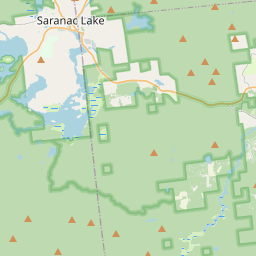
Make a weekend of it.
Closest editorial picks for a meal, a scoop, a pint, a bed, and a sight worth your time.
Eat.
4- Red Fox11.6 mi
The Red Fox Restaurant is a longtime Saranac Lake landmark known for its Steak, Seafood, and Italian dishes, offered in a spacious Adirondack-style setting.
- Blue Line Brewery12.0 mi
A brewery and restaurant on Lake Flower Avenue in Saranac Lake, doing thin-crust South Shore-style bar pizza and Wing Wars-winning wings alongside the house beer. The third-oldest brewery in the Adirondacks.
- Tail O' the Pup12.0 mi
A roadside stop offering barbecue, seafood, and casual fare, with a history stretching back over a century.
- ADK Street Eats12.0 mi
Food trailer at 1179 NY-86 in Ray Brook, between Lake Placid and Saranac Lake. Chef-driven menu of tacos (Carne Asada, Al Pastor), lobster rolls, ADK Spiedies, and Rochester Hot Meats. Tuesday–Sunday.
Sip.
4- Blue Moon12.5 mi
Blue Moon Café in Saranac Lake offers dine-in, pick-up, and curbside delivery services. Guests can enjoy weekly specials, restaurant menus, baked goods, coffee, grocery items, and adult beverages.
- Origin Coffee12.6 mi
Origin Coffee Co is a specialty coffee shop with locations in Lake Placid and Saranac Lake serving a chef-driven breakfast and lunch menu.
- Nori's Village Market12.7 mi
Nori's Village Market and Riverside Cafe offers a market with organic and local produce, bulk foods, coffee, and teas, alongside a cafe serving natural, vegetarian, vegan, gluten-free, and local meat options.
- Origin Coffee14.4 mi
Origin Coffee Co. is a specialty coffee shop with locations in Lake Placid and Saranac Lake, offering a chef-driven breakfast and lunch menu served all day. It serves as a community gathering spot for locals and Adirondack travelers.
Sweet.
4- Mountain Mist Custard11.6 mi
A summer fixture on the shore of Lake Flower in Saranac Lake, with picnic tables and a dock you can tie a boat to. Frozen custard and soft serve with weekly-rotating flavors, shakes, and sundaes.
- Donnelly's Soft Ice Cream11.7 mi
A fourth-generation Saranac Lake institution on a former dairy farm, serving exactly one rotating soft-serve flavor each day — twisted with vanilla on the same 1953 machine. Cash only; check the daily flavor. Memorial Day to Labor Day.
- Mark Twain Maple Works11.8 mi
Mark Twain Maple Works produces New York State maple syrup on the shore of Saranac Lake in the Adirondack Park. They have been making syrup since 2013, expanding their operation and offering various grades.
- Skyline Ice Cream13.1 mi
A roadside soft-serve stand on Route 30 in Tupper Lake since 1985 — vanilla and black-raspberry twists, gelato, Dole Whip, and Michigans, now with an expanded burger-and-fries menu.
Drink.
4- Ray Brook Brewhouse12.0 mi
Ray Brook Brewhouse is a unique brewery in Ray Brook, NY, offering wild and traditional brews paired with adventurous dishes made from local and exotic ingredients.
- Bitters & Bones12.7 mi
Saranac Lake's only downtown brewery, restaurant, and bar, Bitters & Bones offers craft beer brewed upstairs, fresh local cuisine for breakfast, lunch, and dinner, and craft cocktails. It features rooftop decks and unique private event spa…
- RiverTrail Beerworks12.8 mi
RiverTrail Beerworks is Saranac Lake’s only riverfront brewpub, located on the Saranac Lake River Walk and Rail Trail. It features a heated patio, firepits, two golf simulators, and serves lunch and dinner daily with house-brewed beers and…
- Lakeview Lanes & The Foul Line Sports Bar13.3 mi
Lakeview Lanes & The Foul Line Sports Bar in Tupper Lake offers 8 lanes of bowling, an arcade, a sports bar, and outdoor seating with food and drinks for family fun.
Stay.
4- Saranac Lake Islands Campground - Campsite #707.2 mi
Saranac Lake Islands Campground offers primitive, boat-access-only island campsites on Lower Saranac Lake, providing extensive boater recreation and access to four additional lakes via a system of locks.
- Saranac Lake Islands Campground Campsite 717.3 mi
Saranac Lake Islands Campground offers primitive, boat-access-only camping on Lower Saranac Lake. It provides extensive boater recreation and direct access to four other lakes via a system of locks.
- Saranac Lake Islands Campground - Campsite #747.8 mi
The Lower Saranac Lake Islands provide miles and miles of boater recreation and direct access to four other lakes through a set of locks which allow your vessel to be raised or lowered to the right water level.
- Saranac Lake Islands Campground - Campsite #778.1 mi
Explore the Lower Saranac Lake Islands, offering extensive boater recreation and access to four other lakes via locks. Camp on designated island sites for a primitive, boat-access-only experience.
See.
4- Camp Santanoni10.7 mi
Built by the wealthy Pruyn family, Camp Santanoni is a publicly-owned National Historic Landmark, offering visitors a glimpse into the early Adirondack Great Camp era and opportunities for outdoor recreation.
- Sail Adirondacks: Saranac Lake-Lake Placid11.1 mi
A crewed sailboat charter operation with bases in Saranac Lake and Port Henry on Lake Champlain, running learn-to-sail lessons and skippered cruises on a fleet of classic sailboats.
- The Wild Center12.1 mi
Live animals, hands-on exhibits & forest trails connect guests with the Adirondacks.
- Ice Palace at the Saranac Lake Winter Carnival12.5 mi
The Ice Palace is a prominent feature of the Saranac Lake Winter Carnival, a historic annual celebration in New York State established in 1897.
Add to the record.
Free, takes thirty seconds. Yours forever.
Every page on this site gets better when readers contribute. Mark a peak you’ve climbed, drop a photo, file a field note, or flag a correction — every addition makes the next visitor’s page better.
File a report.
Trail conditions, water level, bug pressure, blowdown. The kind of detail that helps the next person plan.
Write a field note →Spot something off?
Wrong elevation, outdated access notes, a coordinate that's drifted. We'd rather hear it than miss it.
Suggest an edit →
Frequently asked.
- How long is the Donaldson Trail?The Donaldson Trail is approximately 0.00 miles (0.0 kilometers) — a short out-and-back suitable for most fitness levels.
- How difficult is the Donaldson Trail?The Donaldson Trail is rated mountain hiking (SAC T2) — partly steep, with sections that benefit from hiking boots and a confident step. Check current DEC advisories for closures, washouts, or seasonal restrictions before heading out.