

Northville-Placid Trail Spur Trail.
This 0.1-mile connector runs from the Northville-Placid Trail to Spruce Lake on a dirt tread. It's the fastest way to reach the water if you're through-hiking the NPT or camping at the lake. The ground surface holds up well enough for cross-country skiers in winter when the lake becomes a destination in its own right.
- Leg-stretcherShort and nearly flat — an hour or less
Seasonal pattern for this trail · tops out ~2,441 ft · live closures appear above
- GroundSurface
- NoWheelchair
- YesSki
- goodTrail visibility
Read the line before you walk it.
What the trailhead is doing today.
Where the hike begins.
Guides, outfitters & shuttles.
If you’re already out here.
Speculator.
The corner of the Park this trail calls home — its hamlets, waters, lodging, and the rest of its field record.
Read the Region→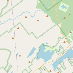
Make a weekend of it.
Closest editorial picks for a meal, a scoop, a pint, a bed, and a sight worth your time.
Eat.
4- Oxbow Inn9.3 mi
Oxbow Inn is a welcoming restaurant and bar in Lake Pleasant offering great pizza, local beef burgers, and a wide selection of 16 draft beers. Enjoy casual dining, live music, and an outdoor deck with fire pits and lake views.
- Firetower Pizza12.4 mi
Hand-tossed pizzeria in Speculator with specialty pies named after Adirondack peaks (Mt Marcy, Snowy Mountain, Whiteface). Wings, baked ziti, white clam pie. Cozy waiting area with retro jukebox and arcade.
- Charlie Johns Store12.4 mi
Opened in 1939, Charlie Johns Store is Speculator's anchor general store — 12,000 square feet of full grocery selection, produce, fresh meats, a full deli, bakery, and hardware. Purchased from Charlie Johns in 1971 by Dean Lane, the Lane family has owned and operated it since.
- Seventh Lake House15.9 mi
Rustic space with a lake view preps classic & contemporary American dishes from seasonal goods.
Sip.
4- The PERKS of Speculator12.6 mi
Speculator coffee shop and bakery at 2855 NY-30. Specialty coffee, espresso, fresh-baked bagels and pastries, plus breakfast and lunch sandwiches. Gluten-free options across the bakery case.
- Blue Line Coffee House17.6 mi
Blue Line Coffee House offers Adirondack-inspired apparel, handcrafted mugs, and mountain-themed gifts, along with pre-packaged coffee and coffee accessories. Products are available for nationwide shipping, and local customers can order dr…
- Tamarack Cafe17.6 mi
Tamarack Cafe in downtown Inlet serves a wide variety of breakfast and lunch options, from traditional favorites and specialty bowls to creative salads, sandwiches, and burgers. The cafe also features an 18-hole mini-golf course.
- Uncle Carl's Coffee18.5 mi
Uncle Carl's Coffee serves expertly crafted coffees, artisan teas, pastries, and light savory bites. They also offer daily quiche and bagels, along with homemade soups, frozen meals, local meats, and cheeses.
Sweet.
4- Speculator Creamery12.3 mi
A family-run village creamery anchoring Speculator's tiny downtown near Lake Pleasant — a genuine community summer hub. Wide-ranging soft-serve flavors, the 16oz Nor'Easter blend, and hand-dipped hard ice cream. Roughly May through September.
- Northern Lights Creamery Inc.17.0 mi
An Inlet institution for 40-plus years, a short walk from Arrowhead Park on Fourth Lake — soft serve, homemade gelato, floats, flurries, and specialty sundaes.
- Benny’s Ice Cream21.9 mi
A family-run, locally loved scoop shop on Old Forge's Main Street — hand-scooped hard flavors and soft serve.
- Pied Piper21.9 mi
A circa-1950s soft-serve and frozen-custard stand locals treat as a permanent fixture — the walk-up window after a day on the Fulton Chain or at the water park. Three daily soft-serve flavors plus around 20 hard flavors.
Drink.
4- Acorn Pub & Eatery at Oak Mountain12.4 mi
Acorn Pub & Eatery is a dining option at Oak Mountain, offering a place to eat and drink.
- Lemon Tree Brewery12.6 mi
Lemon Tree Brewery is a brewery and taproom located in Speculator, NY, steps from Lake Pleasant. It offers house brews like SASQUATCH HAZY IPA and Blueberry Wheat, along with other local NY State micro-brewed beers and wines in a relaxed s…
- Daiker's20.0 mi
Daikers is an Adirondack pitstop in Old Forge, NY, offering seasonal and local dining with a deck overlooking Fourth Lake. Their caring and committed staff ensure a fantastic experience for guests.
- Slickers Adirondack Tavern21.8 mi
Slickers Adirondack Tavern, established in 1984, offers a classic tavern experience with a focus on quality ingredients. They are well-known for their signature French Dip Sandwich.
Stay.
4- The Inn on Piseco Lake7.4 mi
Established in 1892 as the Irondequoit Inn, the historic Inn on Piseco Lake is a 600-acre lakefront retreat in the Hamilton County hamlet of Piseco — nine guest rooms, two-bedroom cabins that sleep six, beachfront and wooded campsites, and a restaurant open to the public. The Northville-Placid Trail crosses nearby. A rare survivor of the late-19th-century Adirondack hotel era.
- Wilbur's Cottages10.1 mi
Secluded housekeeping cabins on Sacandaga Lake in the Adirondacks. Sandy beach, dock, boats. Swimming, boating, fishing, hiking, fireplaces.
- Moffit Beach Campground10.3 mi
A 247-site DEC campground on Sacandaga Lake near Speculator at 1,730 feet elevation, with flat well-wooded sites under white pines and hardwoods. Pets allowed on a 6-foot leash.
- Moffitt Beach State Campground10.9 mi
This popular state campground offers 260 sites among tall white pines, with many enjoying direct access to Sacandaga Lake for fishing, boating, and swimming.
See.
4- Speculator Historical Museum12.3 mi
A small local-history museum on Route 8 in Speculator inside the original Lake Pleasant Town Hall and Library. Open weekends Memorial Day through August, plus weekday hours in summer.
- Ampersand Christine Falls15.0 mi
Ampersand Energy LLC.
- Great Camp Sagamore15.9 mi
Great Camp Sagamore is a historic Adirondack Great Camp offering multi-day programs, overnight stays, and daily activities focused on history, arts, outdoor recreation, and wellness.
- Raquette Lake Navigation Cruise19.3 mi
Raquette Lake Navigation Company offers dining, sightseeing, and special event cruises on Raquette Lake in New York. This family-owned and operated business has been providing scenic experiences aboard the W.W. Durant since 1991.
Add to the record.
Free, takes thirty seconds. Yours forever.
Every page on this site gets better when readers contribute. Mark a peak you’ve climbed, drop a photo, file a field note, or flag a correction — every addition makes the next visitor’s page better.
File a report.
Trail conditions, water level, bug pressure, blowdown. The kind of detail that helps the next person plan.
Write a field note →Spot something off?
Wrong elevation, outdated access notes, a coordinate that's drifted. We'd rather hear it than miss it.
Suggest an edit →
Frequently asked.
- How long is the Northville-Placid Trail Spur Trail?The Northville-Placid Trail Spur Trail is approximately 0.06 miles (0.1 kilometers) — a short out-and-back suitable for most fitness levels.
- How difficult is the Northville-Placid Trail Spur Trail?The Northville-Placid Trail Spur Trail is rated easy hiking (SAC T1) — broad, well-marked path suitable for most fitness levels in sturdy shoes. Check current DEC advisories for closures, washouts, or seasonal restrictions before heading out.