

44.86°N · 74.66°W · CARTO Voyager
§ The Trails · Tupper Lake
Unnamed trail.
this trail runs 0.8 miles (1.3 km) — a short walk. It is also open to horseback riding.
Length0.8 mi
DifficultyNot rated
Book time15mguidebook pace
Field dataOpenStreetMap geometry · elevation sampled ~150 m
§ Good for
- Leg-stretcherShort and nearly flat — an hour or less
Our read, from the trail’s length, climb & grade.
§ When to go
PrimePrime season — and peak color
- Peak foliage window — color starts up high and works down the valleys through mid-October.
J
F
M
A
M
J
J
A
S
O
N
D
Seasonal pattern for this trail · live closures appear above
§ The Route · 0.8 Miles Mapped
Directions to the Trailhead→Read the line before you walk it.
Plate No. 1 — Unnamed trailThe Atlas · CARTO
§ Conditions on the Trail
What the trailhead is doing today.
§ Near This Trail
All Trails→If you’re already out here.
§ The Region
Tupper Lake.
The corner of the Park this trail calls home — its hamlets, waters, lodging, and the rest of its field record.
Read the Region→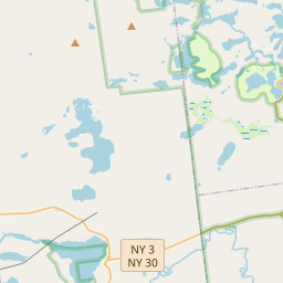
§ The Field Notes
Add to the record.
§ Reader account
Start your Logbook.
Free, takes thirty seconds. Yours forever.
Every page on this site gets better when readers contribute. Mark a peak you’ve climbed, drop a photo, file a field note, or flag a correction — every addition makes the next visitor’s page better.
03Field Note
File a report.
Trail conditions, water level, bug pressure, blowdown. The kind of detail that helps the next person plan.
Write a field note →04Corrections
Spot something off?
Wrong elevation, outdated access notes, a coordinate that's drifted. We'd rather hear it than miss it.
Suggest an edit →Photos, field notes, and corrections are reviewed before they appear publicly. Logbook entries post immediately.§ Maintain or steward this trail? Get in touch →
§ From the field guides
All field guides →


§ Questions
Frequently asked.
- How long is the this trail?The this trail is approximately 0.81 miles (1.3 kilometers) — a short out-and-back suitable for most fitness levels.